Abstract
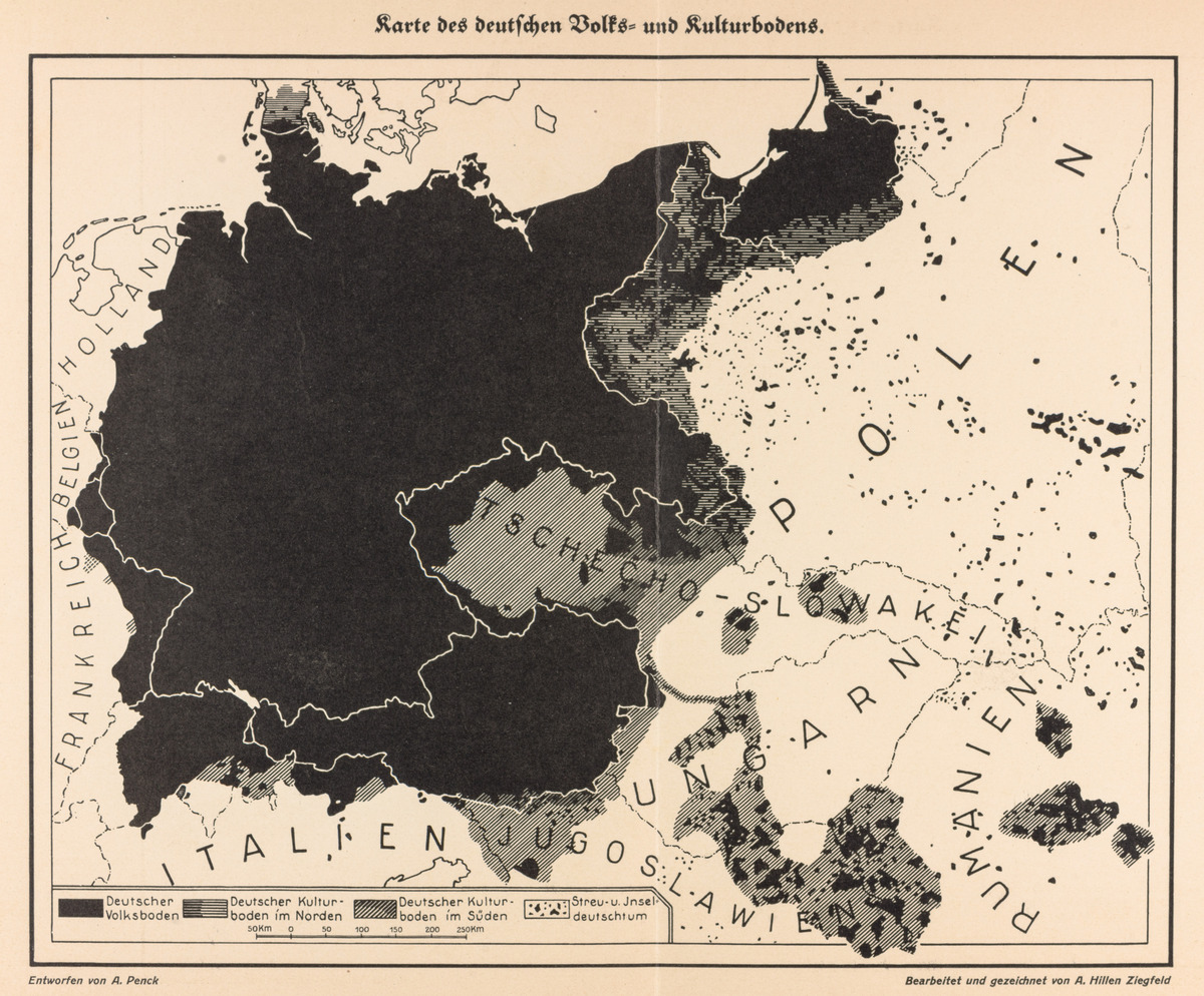
Maps showing the distribution of German-speaking peoples in Europe
had circulated since the nineteenth century, but advances in printing
technology in the 1920s enabled them to do so even more widely. These
maps took on more explicitly revisionist geopolitical agendas after the
First World War as a reaction to Germany’s territorial losses and a
reflection of the growing influence of geographers who engaged in
Volks- und Kulturbodenforschung
(research into the rootedness of ethnic and cultural groups in
particular spaces). Institutions such as the
Deutsche Akademie, founded in 1925,
and the Stiftung für deutsche Volks- und
Kulturbodenforschung, founded in 1926, propagated the notion that
central Europe was an inherently German space. Maps such as this one
promoted the idea that Germany’s “natural borders” extended beyond the
official ones that the Treaty of Versailles had drawn, and they
cultivated a yearning for territorial revision and “Lebensraum” (living
space) on which the Nazi Party soon capitalized.
The author of this particular map, the geographer Albrecht Penck, had
established a reputation prior to the First World War as one of the
world’s leading researchers in climatology, glaciation, and the study
more broadly of how physical features manifest the underlying geological
conditions. During and after the war, however, Penck grew increasingly
interested in studying Germany’s ethnic and cultural presence throughout
central Europe. His ideas attracted conservative nationalists and,
later, National Socialists, who drew on Penck’s writings to justify
their own calls for Germany’s territorial expansion throughout central
Europe.
The 1925 book in which Penck’s map and accompanying article appeared
was edited by the ethnologist Karl Christian von Loesch, a founding
member in 1922 of the Deutscher Schutzbund
für das Grenz- und Auslandsdeutschtum [the German Protective League
for Germandom in the Borderlands and Abroad]. The League made sure that
the preservation of the rights and livelihoods of Germans throughout
central and eastern Europe remained a priority for the German
government. Longer term, it nurtured the public’s long-term desire to
annex the lands where these Germans lived, and this map clearly served
that function. Loesch’s own article in this 1925 book promoted his
concept of “Umvolkung,” which expressed both the fear that German
communities abroad were being de-Germanized by their respective postwar
states—such as Poland or Czechoslovakia, for instance— and the potential
for programs and policies to maintain and even to re-Germanize those
same communities. During the Weimar Republic, the maintenance effort
took the form of diplomatic negotiations and financial subsidies, but,
under the Nazi regime, the concept of “Umvolkung” would guide the
regime’s agenda of military conquest and forced resettlements throughout
the east.