Source
Source: Die Unionisierung Mitteleuropas! Ein Wegweiser zum Dauerfrieden, P.A. M. Vienna: Selbstverlag des Verfassers, 1920. Available online at: https://digital.library.cornell.edu/catalog/ss:19343441
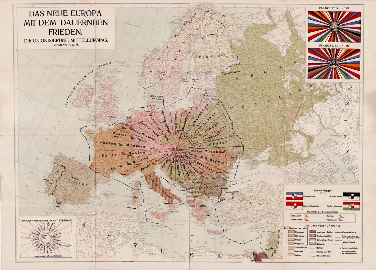
The pamphlet titled Die Unionisierung Mitteleuropas! Ein Wegweiser zum Dauerfrieden that accompanies this map challenges the Treaty of Versailles, which placed humiliating and ruinous conditions on the defeated Germany: “Does anyone really seriously believe that the consequences of the peace negotiations so far have secured eternal peace?” (p. 2) In his preface the author claims, “In my project … a new human nature emerges from all the good and noble sides of every present nation, in which racial hatred does not prevail as before, but the love of the people prevails.” Choosing to remain anonymous at the time of publication, the author wrote on the last page, “I have informed a Notary of my name, profession and role as author and editor of this work of peace, and it will be announced only when the four principal Nations in the Union have expressed their judgment publicly.” (p. 24) It was likely P.A. Maaß, the son of Otto Maaß, owner of the publishing house Otto Maaß’ Söhne, and this map formed part of his 24-page blueprint for the complicated utopian scheme. Maaß’ future Central European Union was to be composed of 24 “cantons,” each a long, narrow wedge named after its capital city. The odd wedge shape was adopted “only in order to create the most concessionary and fairest part of the whole territory of Central Europe,” so that traditional disputes among European peoples “were solved and buried forever.” (p. 10) The wedges were to meet at St. Stephen’s Cathedral in Vienna, to be renamed “Sankt Stephan” and designated the capital of the Union. The Cantons cut across cultural and ethnic lines as well as traditional state borders, and “Throughout the Union, only four Nations are recognized: Romanic, Germanic, Slavic and Magyar. Each of these Nations, with the exception of the latter, is divided into different peoples, all belonging to the same tribe of the Nation. The Romanic Nation is divided into French, Italians, Rumanians— the Germanic Nation into Prussians, Bavarians, Dutch, Saxons, Austrians, the Tyrolians, etc.—The Slavic Nation into in Poles, Czechs, Moravians, Ruthenians, Croatians, Serbs, etc.” (p. 14). The four Nations are shown in different colors on the map, and each Canton includes people from at least two Nations. The Canton of Brussels, for example, includes Romans, Germans and Slavs. Among other particulars outlined in the pamphlet, suffrage was to be extended to all those over age 20, with the exception of married women (p. 14), and Esperanto was to be the official language.
Source: Die Unionisierung Mitteleuropas! Ein Wegweiser zum Dauerfrieden, P.A. M. Vienna: Selbstverlag des Verfassers, 1920. Available online at: https://digital.library.cornell.edu/catalog/ss:19343441
Cornell University – PJ Mode Collection of Persuasive Cartography