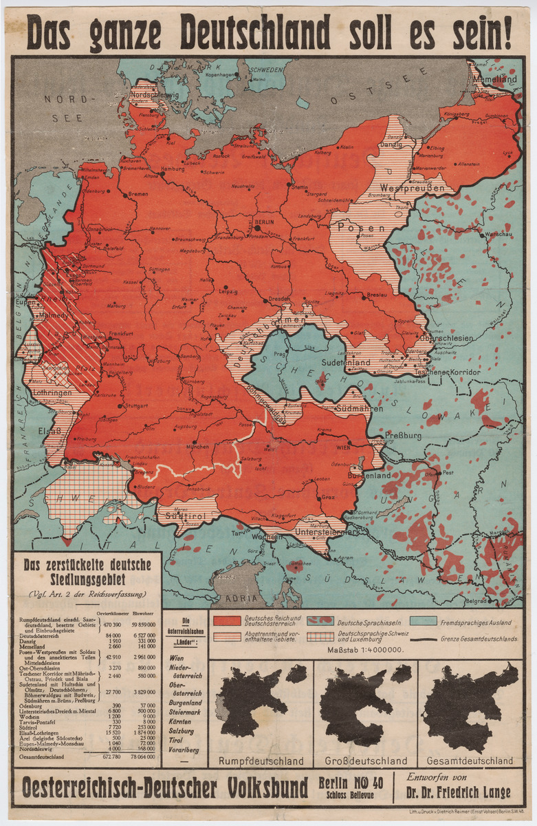
Abstract
This map was printed and distributed by the Austro-German People’s
League [Oesterreichisch-Deutscher
Volksbund], which lobbied after World War I for the union of
Germany and Austria, referred to as an
Anschluss. Its title, “Das ganze
Deutschland soll es sein!”, references Ernst Moritz Arndt’s 1813 poem,
“Des Deutschen Vaterland,” a nineteenth-century rallying cry for German
unification. The League grew out of early calls in 1918 by a few
Austrians living in Berlin who saw such a union as an expression of
national self-determination and thus fully in the spirit of U.S.
President Woodrow Wilson’s vision for the postwar settlement. Although
the League’s membership only numbered at around 20,000 at its peak, it
drew prominent German politicians and civic leaders to its ranks and
opened branches across Germany and, after 1925, throughout Austria as
well.
The legend in the lower left of the map calls attention to Article 2
of the Weimar Constitution as providing a legal basis for Germany’s
union with Austria. It states, “The territory of the Reich consists of
the territories of the German states. Other territories may be
incorporated into the Reich by way of Imperial Law if their populations
desire it by virtue of their right to self-determination.” [“Das
Reichsgebiet besteht aus den Gebieten der deutschen Länder. Andere
Gebiete können durch Reichsgesetz in das Reich aufgenommen werden, wenn
es ihre Bevölkerung kraft des Selbstbestimmungsrechts begehrt.”] Despite
the force of this assertion, the League knew full well that both the
Treaty of Versailles (between Germany and the victorious powers) and the
Treaty of Saint-Germain (between Austria and the victorious powers)
explicitly prohibited a political union of the two countries. The League
sought, therefore, both to shift international opinion about an
Anschluss and to rally national
opinion in favor of it, the latter being the clear aim of this map.
This map was first published in 1925, an especially active year for
the League, since it opened its first chapters in Austria that summer
and began receiving funding from the German ministries of the interior
and foreign affairs that year as well. The map’s creator, Friedrich
Lange, born in 1885, was a librarian and cartographer with a particular
interest in mapping the distribution of German speakers throughout
Europe as well as in drawing attention to territories that Germany had
lost after World War I and that ostensibly belonged back within the
German nation. In the same year that this map appeared, Lange also
published the book Deutschlands gerechte
Grenzen. Mit 14 Zeichnungen und 1 Landkarte
[Germany’s Rightful Borders. With 14
Sketches and 1 Map], under the pseudonym “Adriaticus.” Because his
interests aligned so closely with those of the Nazi regime, Lange went
on to produce many more maps and books during the Third Reich than the
Weimar Republic.